Published: January 2003
|
|
For more than 10 years, the aviation industry has been developing a positioning and landing system based on the Global Navigation Satellite System (GNSS). These efforts culminated in late 2001, when the International Civil Aviation Organisation (ICAO) approved an international standard for a landing system based on local correction of GNSS data to a level that would support instrument approaches. The ICAO Standards and Recommended Practices (SARPS) define the characteristics of a Ground-Based Augmentation System (GBAS) service that can be provided by an airport authority or an Air Traffic Service provider. The GBAS service provides the radiated signal in space that can be used by suitably equipped airplanes as the basis of a GNSS landing system (GLS). The initial SARPS support an approach service. Future refinements should lead to full low-visibility service (i.e., takeoff, approach, and landing) and low-visibility taxi operations.
This article describes
1. ELEMENTS OF THE GLS
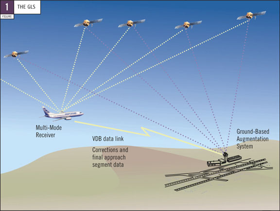
The GLS consists of three major elements — a global satellite constellation that supports worldwide navigation position fixing, a GBAS facility at each equipped airport that provides local navigation satellite correction signals, and avionics in each airplane that process and provide guidance and control based on the satellite and GBAS signals (fig.1).

The GLS uses a navigation satellite constellation (e.g., the U.S. Global Positioning System [GPS], the planned European Galileo System) for the basic positioning service. The GPS constellation already is in place and improvements are planned over the coming decades. The Galileo constellation is scheduled to be available in 2008.
The basic positioning service is augmented locally — at or near the airport — through a GBAS radio transmitter facility. Because the ground facility is located at a known surveyed point, the GBAS can estimate the errors contained in the basic positioning data. Reference receivers in the GBAS compare the basic positioning data with the known position of the facility and compute corrections on a satellite-by-satellite basis. The corrections are called pseudo-range corrections because the primary parameter of interest is the distance between the GBAS facility and individual satellites. The satellite constellation is continuously in motion, and satellites ascend and descend over the horizon when observed from any point on Earth. The GBAS calculates corrections for all the satellites that meet the specified in-view criteria and transmits that information to the nearby airplanes over a VHF Data Broadcast (VDB) data link.
Boeing airplanes that are currently being produced contain Multi-Mode Receivers (MMR) that support Instrument Landing System (ILS) and basic GPS operations. These MMRs can be modified to support GLS and potentially Microwave Landing System operations. The GLS capability is supported through the addition of a receiver and processing in the MMRs of the GBAS data provided through the VDB data link. The MMRs apply the local correction data received from the GBAS to each satellite that the airplane and GBAS share in common. Because of position and altitude differences and local terrain effects, the GBAS and the airplane may not necessarily be observing the same combination of satellites. The airplane systems only use satellite information that is supported by correction data received from the GBAS. When the airplane is relatively close to the GBAS station, the corrections are most effective, and the MMRs can compute a very accurate position. Typical lateral accuracy should be greater than or equal to 1 m.
2. OPERATIONS USING THE GLS
A single GBAS ground station typically provides approach and landing service to all runways at the airport where it is installed. The GBAS may even provide limited approach service to nearby airports. Each runway approach direction requires the definition of a final approach segment (FAS) to establish the desired reference path for an approach, landing, and rollout. The FAS data for each approach are determined by the GBAS service provider and typically are verified after installation of the GBAS ground station.
One feature that differentiates the GLS from a traditional landing system such as the ILS is the potential for multiple final approach paths, glideslope angles, and missed approach paths for a given runway. Each approach is given a unique identifier for a particular FAS, glideslope, and missed approach combination. FAS data for all approaches supported by the particular GBAS facility are transmitted to the airplane through the same high-integrity data link as the satellite range correction data (i.e., through the VDB data link). The MMRs process the pseudo-range correction and FAS data to produce an ILS-like deviation indication from the final approach path. These deviations are then displayed on the pilot's flight instruments (e.g., Primary Flight Display [PFD]) and are used by airplane systems such as the flight guidance system (e.g., autopilot and flight director) for landing guidance.
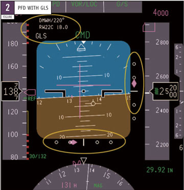
 The ILS-like implementation of the GLS was selected to support common flight deck and airplane systems integration for both safety and economic reasons. This implementation helps provide an optimal pilot and system interface while introducing the GLS at a reasonable cost. The use of operational procedures similar to those established for ILS approach and landing systems minimises crew training, facilitates the use of familiar instrument and flight deck procedures, simplifies flight crew operations planning, and ensures consistent use of flight deck displays and annunciations. For example, the source of guidance information (shown on the PFD in fig. 2) is the GLS rather than the ILS. The scaling of the path deviation information on the pilot's displays for a GLS approach can be equivalent to that currently provided for an ILS approach. Hence, the pilot can monitor a GLS approach by using a display that is equivalent to that used during an ILS approach.
Figure 2 shows a typical PFD presentation for a GLS approach. The Flight Mode Annunciation on the PFD is "GLS" for a GLS approach and "ILS" for an ILS approach.
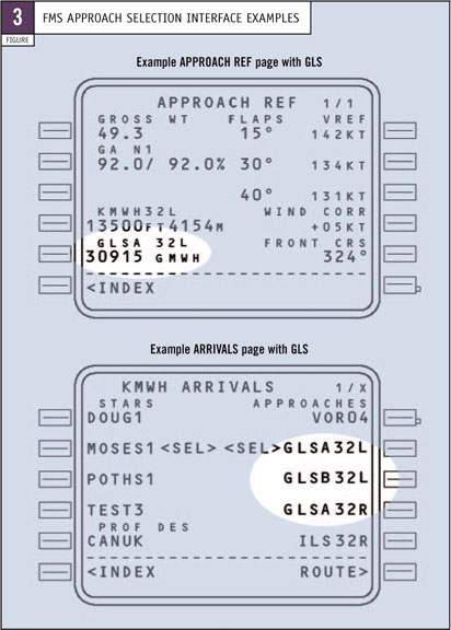
 To prepare for a GLS approach, the pilot selects GLS as the navigation source and chooses the particular approach to be flown. This is accomplished by selecting a GLS approach through the FMS (fig. 3) or by entering an approach designator on a dedicated navigation control panel (fig. 4). In either case, a unique five-digit channel number is associated with each approach. With the FMS interface, the pilot does not need to enter a channel number; tuning is accomplished automatically based on the approach selected, just as is now done for ILS. However, for an airplane equipped with separate navigation tuning panels, the pilot tunes the MMRs by entering a GLS channel number in that panel. This is similar to the equivalent ILS flight deck interface where a pilot tunes the ILS by using a designated VHF navigation frequency. As with the ILS, certain GLS identification data are available on other FMS pages such as the APPROACH REF page, which shows the runway identifier, GLS channel, and associated approach identifier (fig. 3).
Regardless of the selection method, the five-digit GLS channel number is encoded with the frequency to be used for the VDB data link receiver and with an identifier for the particular approach and missed approach path (FAS data set) that corresponds to the desired approach.
 Figure 4 shows a navigation control panel used to tune navigation radios, including GLS, for the 737-600/-700/-800/-900.
The approach plate shows the channel number for each approach and a four-character approach identifier to ensure consistency between the selected channel and the approach procedure chosen by the pilot. The approach identifier is read from the FAS data block and displayed to the pilot on the PFD to provide positive confirmation that the desired approach has indeed been selected.
 Figure 5 shows a typical GLS approach procedure. The procedure is similar to that used for ILS except for the channel selection method and the GLS-unique identifier. The approach chart is an example of a Boeing flight-test procedure and is similar to a chart that would be used for air carrier operations, with appropriate specification of the landing minima.
 Figure 6 is an example of a possible future complex approach procedure using area navigation (RNAV), Required Navigation Performance (RNP), and GLS procedures in combination. Pilots could use such procedures to conduct approaches in areas of difficult terrain, in adverse weather, or where significant nearby airspace restrictions are unavoidable. These procedures would combine an RNP transition path to a GLS FAS to the runway. These procedures can also use GBAS position, velocity, and time (PVT) information to improve RNP capability and more accurately deliver the airplane to the FAS.
The GBAS is intended to support multiple levels of service to an unlimited number of airplanes within radio range of the VDB data link. Currently, ICAO has defined two levels of service: Performance Type 1 (PT 1) service and GBAS Positioning Service (GBAS PS). PT 1 service supports ILS-like deviations for an instrument approach. The accuracy, integrity, and continuity of service for the PT 1 level have been specified to be the same as or better than ICAO standards for an ILS ground station supporting Category I approaches. The PT 1 level was developed to initially support approach and landing operations for Category I instrument approach procedures. However, this level also may support other operations such as guided takeoff and airport surface position determination for low-visibility taxi.
The GBAS PS provides for very accurate PVT measurements within the terminal area. This service is intended to support FMS-based RNAV and RNP-based procedures. The improved accuracy will benefit other future uses of GNSS positioning such as Automatic Dependent Surveillance — Broadcast and Surface Movement Guidance and Control Systems.
The accuracy of the GBAS service may support future safety enhancements such as a high-quality electronic taxi map display for pilot use in bad weather. This could help reduce runway incursion incidents and facilitate airport movements in low visibility. The service also may support automated systems for runway incursion detection or alerting.
As important as the accuracy of the GBAS service is the integrity monitoring provided by the GBAS facility. Any specific level of RNP operation within GBAS coverage should be more available because the user receivers no longer will require redundant satellites for satellite failure detection (e.g., Receiver Autonomous Integrity Monitoring).
Because the GBAS PS is optional for ground stations under the ICAO standards, some ground stations may only provide PT 1 service. The messages up-linked through the VDB data link indicate whether or not the ground station supports the GBAS PS and specify the level of service for each approach for which a channel number has been assigned. When the GBAS PS is provided, a specific five-digit channel number is assigned to allow selection of a non-approach-specific GBAS PS from that station. Consequently, the channel selection process allows different users to select different approaches and levels of service.
The GBAS PS and the PT 1 service are not exclusive. If the ground station provides the GBAS PS, selecting a channel number associated with any particular approach automatically will enable the GBAS PS service. The receiver provides corrected PVT information to intended airplane systems as long as the GBAS PS is enabled. ILS-like deviations also are available when the airplane is close enough to the selected approach path.
ICAO is continuing development of a specification for service levels that would support Category II and III approaches.
3. BENEFITS OF THE GLS
From the user perspective, the GBAS service can offer significantly better performance than an ILS. The guidance signal has much less noise because there are no beam bends caused by reflective interference (from buildings and vehicles). However, the real value of the GLS is the promise of additional or improved capabilities that the ILS cannot provide. For example, the GLS can
- Provide approach and takeoff guidance service to multiple runways through a single GBAS facility.
- Optimise runway use by reducing the size of critical protection areas for approach and takeoff operations compared with those needed for ILS.
- Provide more flexible taxiway or hold line placement choices.
- Simplify runway protection constraints.
- Provide more efficient airplane separation or spacing standards for air traffic service provision.
- Provide takeoff and departure guidance with a single GBAS facility.
From the service provider perspective, the GBAS can potentially provide several significant advantages over the ILS. First, significant cost savings may be realised because a single system may be able to support all runways at an airport. With the ILS, each runway served requires an ILS and a frequency assignment for that ILS, which can be difficult because of the limited numbers of available frequencies. Operational constraints often occur with the ILS when an Air Traffic Service provider needs to switch a commonly used ILS frequency to serve a different runway direction. This is not an issue with the GBAS because ample channels are available for assignment to each approach. In addition, because the GBAS serves all runway ends with a single VHF frequency, the limited navigation frequency spectrum is used much more efficiently. In fact, a GBAS may even be able to support a significant level of instrument approach and departure operations at other nearby airports.
The siting of GBAS ground stations is considerably simpler than for the ILS because GBAS service accuracy is not degraded by any radio frequency propagation effects in the VHF band. Unlike the ILS, which requires level ground and clear areas on the runway, the siting of a GBAS VHF transmitter can be more flexible than ILS. The removal of the requirement to provide a large flat area in front of the ILS glideslope alone can represent a very significant savings in site preparation cost and opens up many more locations for low-minima instrument approach service.
Although GBAS accuracy can be affected by multi-path interference, careful siting of GBAS receivers can readily eliminate multi-path concerns because GBAS receivers do not need to be placed near a runway in a specific geometry, as is the case with the ILS or MLS. Hence, this virtually eliminates the requirements for critical protection areas or restricted areas to protect against signal interference on runways and nearby taxiways.
Finally, the GBAS should have less frequent and less costly flight inspection requirements than the ILS because the role of flight inspection for GBAS is different. Traditional flight inspection, if needed at all, primarily would apply only during the initial installation and ground station commissioning. This flight inspection would verify the suitability of the various approach path (FAS) definitions and ensure that the GBAS-to-runway geometry definitions are correct. Because verifying the coverage of the VDB data link principally is a continuity of service issue rather than an accuracy or integrity issue, it typically would not require periodic inspection.
GBAS systems capable of supporting Category II and III operations internationally are envisioned. Airborne system elements that would be necessary for the enhanced GLS capability (e.g., MMR and GLS automatic landing provisions) already are well on the way to certification or operational authorisation. Airborne systems and flight deck displays eventually will evolve to take full advantage of the linear characteristic of the GLS over the angular aspects of the ILS.
4. OPERATIONAL EXPERIENCE
To date, flight-test and operational experience with the GLS has been excellent. Many GLS-guided approaches and landings have bee n conducted successfully at a variety of airports and under various runway conditions.
Both automatic landings and landings using head-up displays have been accomplished safely through landing rollout, in both routine and non-normal conditions.
On the pilot's flight displays, the GLS has been unusually steady and smooth when compared with the current ILS systems even when critical areas necessary for the ILS approaches were unprotected during the GLS approaches.
The Boeing Technology Demonstrator program has used a 737-900 to demonstrate successful GLS operations to airline customers, airplane and avionics manufacturers, airport authorities, Air Traffic Service providers, and regulatory authority representatives.
The GLS represents a mature capability ready for widespread operational implementation. When implemented, the GLS will improve safety, increase capacity, and provide operational benefits to airlines, pilots, passengers, airports, and Air Traffic Service providers. Boeing plans to certify the airborne aspects of the GLS on the 737 by the end of 2003 to support Category I operations, with other models to follow. Work is continuing for the airborne certification of the GLS to support Category II and III operations when suitable GBAS ground facilities are specified and made available.
SummaryThe aviation industry is developing the GLS, a new positioning and landing system that integrates satellite and ground-based navigation information. Potential benefits of the GLS include significantly improved takeoff and landing capability at airports worldwide at reduced cost, instrument approach service at additional airports and runways, and eventual replacement of the ILS. Boeing plans to certify the airborne aspects of the GLS on the 737 by the end of 2003 to support Category I operations, with other models to follow. |
JOHN ACKLAND
SENIOR TECHNICAL FELLOW
AIRPLANE SYSTEMS
BOEING COMMERCIAL AIRPLANES
TOM IMRICH
CHIEF PILOT
RESEARCH
BOEING COMMERCIAL AIRPLANES
TIM MURPHY
TECHNICAL FELLOW
SYSTEMS CONCEPT CENTER
BOEING COMMERCIAL AIRPLANES
| Top of page | Boeing Home | Boeing Commercial | Contact Aero |
Aero Copyright © The Boeing Company. All rights reserved.
