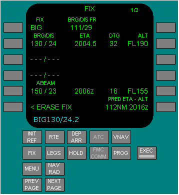
Fix Information

Two identical fix information pages are used to create fixes and waypoints for the HSI. Some of the created waypoints can be copied into the route.
The bearing information is presented in magnetic or true depending on the position of the heading reference switch or airplane location. Refer to FMC Polar Operations, Flight Management Navigation, section 3 1.
Pushing the line select key for one of the BRG/DIS entries copies the fix place/bearing/distance definition into the scratchpad. This fix can be placed into the route on a LEGS page as a waypoint.
FIX - Before entry of a name or identifier, boxes displayed and most data lines are blank. Valid entries are airports, navaids, and waypoints from the navigation database. The selected fix displays on the HSI and is highlighted by a green circle.
BRG/DIS - Valid entries are XXXYYY.Y: • decimal values can be omitted • leading zeros can be omitted for distance entries • distance only entries must start with a slash (/). Distances from the fix display on the HSI as a circle around the fix. When the circle intersects the active route, the ETA, DTG, and predicted altitude at the intersection display for the closest of the two intersections. Bearings from the fix display on the HSI as radial lines from the fix. When the bearing intersects the active route, the ETA, DTG, and predicted altitude at the intersection display.
ETA - displays the estimated time of arrival to the intersection point.
DTG - displays the distance to go to the intersection point.
ALT - displays the predicted altitude at the intersection point.
Push - copies the fix place/bearing/distance into the scratchpad. This fix can be placed in the route on a LEGS or RTE page as a waypoint.
Dashes - Enter a bearing, distance, or both bearing and distance from the fix. A bearing and distance from the fix displays on the HSI as a waypoint fix point. ETA, DTG, and predicted do not display.
Dashes - Enter a bearing, distance, or both bearing and distance from the fix. A bearing and distance from the fix displays on the HSI as a waypoint fix point. ETA, DTG, and predicted do not display.
ABEAM - Displays ABEAM prompt. Push - displays bearing and distance from the fix perpendicular to the nearest segment of the flight plan path, and ETA, DTG, and altitude at the intersection point. Second push - copies the fix place/bearing/distance into the scratchpad. This fix can be placed in the route on a LEGS or RTE page as a waypoint.
ERASE FIX - Push - removes all fix data from the page and the HSI.
BRG/DIS FR: Displays the bearing and distance of the airplane from the fix.
PRED ETA/ALT - Valid entry is altitude, flight level, or time. Time entry must be followed by Z. Entering an altitude or flight level displays the predicted along track distance and altitude or flight level on this line. The predicted airplane position Displays on the HSI route line as a green circle with the entered altitude/flight level or time.
Standard | 11.42.42 | Position Update>