Route Legs
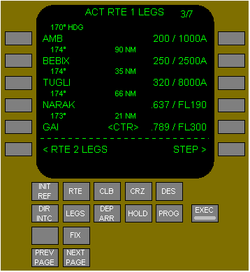
The RTE LEGS page is used to evaluate and modify the planned route of flight during the climb and to add or delete waypoint constraints to comply with the ATC clearance. The data on the RTE LEGS page comes from preflight entries made on the route and departure pages, and from the FMC data bases.
Title format shows route status:
RTE X LEGS - inactive route.
ACT RTE X LEGS - active route.
MOD RTE X LEGS - modified active route.
RTE X LEGS - inactive route.
ACT RTE X LEGS - active route.
MOD RTE X LEGS - modified active route.
Leg segment data in line title:
courses - magnetic (xxx°) or true (xxx° T).
arcs - distance in miles, ARC, turn direction (example: 24 ARC L).
heading leg segments - xxx° HDG.
track leg segments - xxx° TRK.
special procedural instructions from database - HOLD AT, PROC TURN. Calculated great circle route leg directions may be different than chart values. Dashes are shown for an undefined course.
Shows waypoints by name or condition. Active leg is always the first line of the first active RTE X LEGS page. All route waypoints are shown in flight sequence. Waypoints on an airway are included on the route legs page. Waypoints can be modified. Examples:
add waypoints.
delete waypoints.
change waypoint sequence.
connect route discontinuities. Boxes are shown for route discontinuities. Dashes are displayed on the line following the last waypoint on the route.
add waypoints.
delete waypoints.
change waypoint sequence.
connect route discontinuities. Boxes are shown for route discontinuities. Dashes are displayed on the line following the last waypoint on the route.
shows the RTE 2 LEGS.
when RTE 2 LEGS page is shown, prompt changes to RTE 1 LEGS.
when RTE 2 LEGS page is shown, prompt changes to RTE 1 LEGS.
Waypoint speed or altitude constraint in large font. Manual entry allowed in climb or descent phase. Entered by FMC when constraints are part of a procedure. Speed constraint is assumed to be at or below the displayed speed. Valid entries are:
speed - airspeed or Mach - requires an altitude constraint at the same waypoint
altitude in thousands of feet or flight level (19000, 190)
XXX/XXXXX - airspeed/altitude entered simultaneously
XXX/ - airspeed only
XXXXX or /XXXXX - altitude only. Altitude constraint suffixes:
blank - cross at altitude
A - cross at or above altitude
B - cross at or below altitude
both - altitude block. Example: 220A240B.
Distance between the waypoints displayed in nautical miles.
Waypoint speed and altitude predictions are displayed in small font. Dashes are displayed in the descent region prior to descent path calculation. Descent path calculation requires altitude constraint below cruise altitude.
Replaces ACTIVATE or RTE DATA when PLAN mode selected. Push - steps <CTR> to next waypoint. HSI plan mode re-centres.
Pegasus | Alternate | 11.41.8 | Air TurnBack>