Flight Management Navigation -
FMS Navigation Position
- Flight Crew Training Manual - RNP and RNAV Operations
The FMC determines present position from these navigation systems:
- IRS
- Navigation radios (DME, VOR and/or ILS)
- PEGASUS - GPS
The FMC uses its calculated present position to generate lateral steering commands along the active leg to the active waypoint. The FMC requires position data from at least one IRS. All other position sources are validated against the IRS position and increase the accuracy of the FMC position.
FMC Position Update (Basic FMC)
On the ground, the FMC position is based on the IRS position.
Since inertial systems accumulate position errors as a function of time, the position information being used by the FMC is slowly accumulating errors. These position errors can be detected by observing the position of the airplane on the HSI map. If an extended ground delay occurs and a significant map error is noticed the IRS should be realigned and present position re-entered.
As installed
When the autothrottle is engaged for takeoff, the FMC position is automatically updated to the takeoff runway position displayed on the TAKEOFF REF page.
In flight, the FMC position is continually updated from the navigation radios. Updating priority is based on the availability of valid data from the supporting systems but the FMC requires at least one IRS operating in NAV.
The FMC automatically tunes the VOR and DME radios for position updates.
FMC position updates from navigation sensor positions follow this priority:
The selected station identifiers and radio update mode can be seen on the PROGRESS page. The possible modes are, DME - DME, VOR - DME or LOC. (SB changes with the RADIO PURGE prompt on POS REF page 2.)
This information is also displayed on the POS REF page 2.
FMC Position Update (PEGASUS FMC)
FMC position may be manually updated to any of the navigation system positions. This update is accomplished on POS REF page 2.
On the ground, the FMC calculates present position based on IRS and/or the GPS data.
If GPS NAV is OFF, the FMC updates position to the takeoff runway threshold when the EPR switch is pushed. The runway data is on the TAKEOFF REF page. When an intersection takeoff is made, the intersection displacement distance from the runway threshold must be entered on the TAKEOFF REF page. If GPS NAV is ON, the EPR update is inhibited. GPS NAV is on POS REF page 3/4.
In flight, the FMC position is continually updated from the GPS, navigation radios, and the IRS. Updating priority is based on the availability of valid data from the supporting systems.
The FMC automatically tunes the VOR, DME, and ILS radios for position updates.
FMC position updates from navigation sensor positions follow this priority:
- One LOC and GPS (when on the localiser)
- One LOC and co-located DME (when on the localiser)
- GPS
- Two DME stations
- One VOR with a co-located DME
- IRS
The station identifiers of the tuned radio navigation aids are displayed on the POS REF page 2.
| Primary FMC Position Update Source | POS REF page 2/4 |
|---|---|
| GPS | GPS |
| LOC, GPS valid* | LOC-GPS |
| LOC, DME DME valid; GPS invalid* | LOC-RADIO |
| LOC, VOR DME valid; GPS invalid* | LOC-RADIO |
| LOC valid; GPS, DME, VOR invalid* | LOC |
| DME DME valid; GPS invalid | RADIO |
| VOR DME valid; GPS invalid | RADIO |
| GPS, VOR, DME invalid | IRS |
| IRS invalid (no navigation capability) | blank |
|
The FMC changes to LOC updating when:
|
|
Radio Updating
Normally, the FMC automatically tunes the VOR and DME that provides the best available signals for updating the FMC calculated present position. However, the pilot can select frequencies manually or remotely, and if the FMC can continue to use the signals for position updating it will do so.
Manually or remotely tuning both DMEs precludes the FMC from automatically tuning other frequencies for position updating.
When adequate radio updating is not available, the HSI map may display a shift error. This error results in the displayed position of the airplane, route, waypoints and navigation aids being shifted from their actual positions. An across track, undetected map shift may result in the airplane flying a ground track that is offset from the desired track. An along track, undetected map shift may result in the flight crew initiating altitude changes earlier or later than desired. In either case, an undetected map shift may compromise terrain or traffic separation.
Map shift errors can be detected by comparing the position of the airplane on the HSI map with data from the ILS, VOR, DME and ADF systems.
FMC Polar Operations
The FMC automatically starts polar operations when the calculated airplane position enters a polar region.
With the heading reference switch in Normal, automatic switching of all flight display inputs to True North reference occurs when entering a polar region. The change to true heading reference is annunciated by a flashing white box around the word TRU on the HSI. TRUE heading reference can be manually selected when outside the polar region by placing the heading reference switch in the TRUE position. When changing back to magnetic reference, the HSI displays a green box around the word MAG to annunciate the change. If the heading reference is TRU in the descent phase, the HSI displays an amber box around the word TRU.
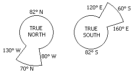
The navigation and display system does not support operations at latitudes greater than 87° North or South.
Polar regions are show in the adjacent graphic. Magnetic headings are not available in these areas.
Navigation Performance - PEGASUS FMC
The FMC uses data from the navigation systems to accurately calculate the position of the airplane. The current FMC position is displayed on line 1 of POS REF page 2. The primary source of update is shown in parentheses above the FMC position. The positions of each of the navigation systems is shown in lines 2 through 4. The flight crew can change the display format from latitude/longitude to bearing/distance format. The bearing/distance is from the FMC position to the individual navigation system position.
Actual Navigation Performance
Actual navigation performance (ANP) is the FMC's current computed position accuracy. It is shown on POS REF page 2 (line 5L) titled ACTUAL. ACTUAL navigation performance is expressed in nautical miles. It represents the radius of a circle centred at the FMC position which defines the limit of the potential error in that position. The smaller the ANP the more accurate the FMC position.
ACTUAL navigation performance is also computed for each of the navigation systems and those values are displayed on POS REF page 2 adjacent to the system name. The systems' ACTUAL navigation performance is equivalent to the one calculated for the FMC.
After a manual position update, the ACTUAL navigation performance of the FMC changes to the ACTUAL navigation performance of the selected navigation system. In the example above, a manual position update to the INERTIAL system would change the FMC ACTUAL navigation performance to 3.9 NM. The FMC then updates from the best available navigation system and eventually, the manual update has no effect on position calculation. Some automatic updates can be inhibited; GPS on POS REF page 3 and VOR/DME updates on the REF NAV DATA page. Inertial and DME/DME updates cannot be inhibited.
Required Navigation Performance
Required navigation performance (RNP) values have been created and published for certain areas of operation and procedures. The RNP, expressed in nautical miles, defines the accuracy of the navigation equipment required to fly the route or procedure for which it is published. ACTUAL navigation performance should not exceed RNP. The FMC triggers the EICAS message UNABLE RNP to alert the flight crew if ANP exceeds RNP. The FMC supplies a default RNP value for takeoff, enroute, oceanic/remote, terminal, and approach phases of flight. RNP is displayed on POS REF page 2. The flight crew may enter an RNP value, if required.
- Flight Crew Training Manual - RNP and RNAV Operations